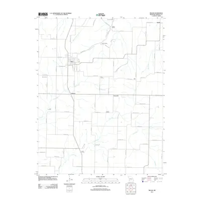
2011 Map of Miller
USGS Topo · Published 2011About this map
Miller serves as the primary hub for this portion of Lawrence County, where a grid of rural routes connects isolated agricultural communities. The landscape is defined by the drainage systems of Stahl Creek, Truitt Creek, and the Sycamore Branch, which have carved out topographical features like Turner Hollow and Piper Hollow. For genealogists, the map is particularly valuable for its documentation of numerous burial grounds scattered across the countryside, including Sycamore Cemetery in the north and Henson Cemetery near the southern boundary. Small, named settlements such as Albatross, Heatonville, Call, and Stinson provide evidence of the area's late 20th-century distribution of crossroads commerce and local identity. The pattern of Farm Roads and numbered Lawrence County routes reflects a persistent reliance on overland transport through the fertile Missouri plains.
Find a feature on this map
65 named features on this map. Tap any name to fly to it.
Don’t see what you’re looking for? This feature index may not catch every label — zoom into the map to look around manually.
Map Details
Editions of this 2011 Miller Map
This is the sole edition of this map. No revisions or reprints were ever made.
Other maps of this area

1886 · Greenfield
USGS Topo · 1:125,000

1888 · Greenfield
USGS Topo · 1:125,000

1919 · Halltown
USGS Topo · 1:62,500

1921 · Stotts City
USGS Topo · 1:62,500

1954 · Springfield
USGS Topo · 1:250,000
1956 · Kings Point
USGS Topo · 1:24,000
1956 · South Greenfield
USGS Topo · 1:24,000
1956 · Everton
USGS Topo · 1:24,000

1958 · Springfield
USGS Topo · 1:250,000

1959 · Springfield
USGS Topo · 1:250,000