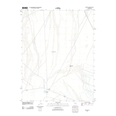
2012 Map of Millers
USGS Topo · Published 2012About this map
Millers stands as a focal point in this high-desert landscape of Nye County, where the infrastructure of transportation intersects with the ephemeral hydrology of the Great Basin. This 2012 survey illustrates a transition in land use, where a historic stop along the western travel corridor is maintained by the Millers Rest Area. The surrounding terrain is defined by the broad expanse of the Big Smoky Valley, punctuated by the drainage of Peavine Creek. This map captures the area just as modern road networks and digital surveying standards were being integrated, providing a precise record of the desert floor's geography. Researchers can trace the layout of this specific Nevada settlement and the persistent watercourses that dictate the survival and placement of human activity in the arid interior.
Find a feature on this map
3 named features on this map. Tap any name to fly to it.
Don’t see what you’re looking for? This feature index may not catch every label — zoom into the map to look around manually.
Map Details
Editions of this 2012 Millers Map
This is the sole edition of this map. No revisions or reprints were ever made.
Other maps of this area

1907 · Tonopah
USGS Topo · 1:250,000

1908 · Tonopah
USGS Topo · 1:250,000

1956 · Tonopah
USGS Topo · 1:250,000

1959 · Tonopah
USGS Topo · 1:250,000

1961 · Lone Mtn
USGS Topo · 1:62,500

1962 · Tonopah
USGS Topo · 1:250,000

1964 · San Antonio Ranch
USGS Topo · 1:62,500
1968 · Crow Springs
USGS Topo · 1:24,000
1968 · Gilbert SE
USGS Topo · 1:24,000
1980 · Outlaw Springs SE
USGS Topo · 1:24,000