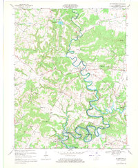
1967 Map of Millerstown
USGS Topo · Published 1971About this map
The Nolin River winds through a deeply incised landscape in this 1967 survey, where the river's path defines the borders between Grayson, Hardin, and Hart Counties. The era marks a significant transition for the valley, as the southern reaches of the river are transformed by the Nolin Reservoir. This inundation zone reaches up to Bush Bend, affecting the historical character of the riverside flats. Away from the water, the plateau is marked by scattered rural communities such as Millerstown and Lacon. Genealogists will find a wealth of specific landmarks, including numerous family and community burial grounds like Phillips Cem, Wooden Cem, and Caswell Cem. Local social centers are anchored by country churches, notably the Little Clifty Ch and Pleasant Valley Ch, while the industrial history of the creeks is preserved in names like Riders Mill.
Find a feature on this map
44 named features on this map. Tap any name to fly to it.
Don’t see what you’re looking for? This feature index may not catch every label — zoom into the map to look around manually.
Map Details
Editions of this 1967 Millerstown Map
3 editions found
Other maps of this area

1925 · Cub Run
USGS Topo · 1:62,500

1932 · Big Clifty
USGS Topo · 1:62,500

1934 · Munfordville
USGS Topo · 1:48,000

1935 · Elizabethtown
USGS Topo · 1:48,000

1937 · Munfordville
USGS Topo · 1:62,500

1938 · Elizabethtown
USGS Topo · 1:62,500

1949 · Sonora
USGS Topo · 1:24,000

1949 · Summit
USGS Topo · 1:24,000

1949 · Big Clifty
USGS Topo · 1:24,000

1949 · Big Clifty
USGS Topo · 1:62,500