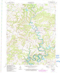
1967 Map of Millerstown
USGS Topo · Published 1993About this map
The Nolin River carves a winding path through the borderlands of Grayson, Hardin, and Hart counties, defining the character of this mid-century landscape. The central settlement of Millerstown sits at a strategic bend in the river, surrounded by a network of rural communities such as Pearman, Royal, and Broad Ford. These hamlets are anchored by local landmarks like Broad Ford Ch and Little Flock Ch, reflecting the generational social fabric of the Kentucky countryside.
Find a feature on this map
47 named features on this map. Tap any name to fly to it.
Don’t see what you’re looking for? This feature index may not catch every label — zoom into the map to look around manually.
Map Details
Editions of this 1967 Millerstown Map
3 editions found
Other maps of this area

1925 · Cub Run
USGS Topo · 1:62,500

1932 · Big Clifty
USGS Topo · 1:62,500

1934 · Munfordville
USGS Topo · 1:48,000

1935 · Elizabethtown
USGS Topo · 1:48,000

1937 · Munfordville
USGS Topo · 1:62,500

1938 · Elizabethtown
USGS Topo · 1:62,500

1949 · Sonora
USGS Topo · 1:24,000

1949 · Summit
USGS Topo · 1:24,000

1949 · Big Clifty
USGS Topo · 1:24,000

1949 · Big Clifty
USGS Topo · 1:62,500