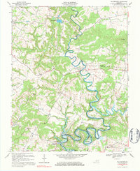
1967 Map of Millerstown
USGS Topo · Published 1984About this map
The Nolin River winds through the heart of this landscape, its tight meanders carving deep into the terrain at Bush Bend and around Joyce Island. This 1967 survey captures the area just as the Nolin Reservoir was becoming a defining feature of the southern river valley, where the Us Res BDY indicates federal land management near the water's edge. This was a world of small mills and rural community centers, with Wheelers Mill and Riders Mill marking the local river-driven economy.
Find a feature on this map
59 named features on this map. Tap any name to fly to it.
Don’t see what you’re looking for? This feature index may not catch every label — zoom into the map to look around manually.
Map Details
Editions of this 1967 Millerstown Map
3 editions found
Other maps of this area

1925 · Cub Run
USGS Topo · 1:62,500

1932 · Big Clifty
USGS Topo · 1:62,500

1934 · Munfordville
USGS Topo · 1:48,000

1935 · Elizabethtown
USGS Topo · 1:48,000

1937 · Munfordville
USGS Topo · 1:62,500

1938 · Elizabethtown
USGS Topo · 1:62,500

1949 · Sonora
USGS Topo · 1:24,000

1949 · Summit
USGS Topo · 1:24,000

1949 · Big Clifty
USGS Topo · 1:24,000

1949 · Big Clifty
USGS Topo · 1:62,500