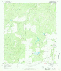
1967 Map of Millersview
USGS Topo · Published 1969About this map
Millersview serves as the primary hub of this Concho County landscape, situated near the convergence of numerous drainage systems. The terrain is defined by the branching arms of Mustang Creek, including its North Fork and West Fork, which are punctuated by engineered water controls. Large areas marked for controlled inundation surround prominent spillways, such as the one at Spillway Elev 1699, reflecting mid-century water management efforts in this part of West Texas.
Find a feature on this map
15 named features on this map. Tap any name to fly to it.
Don’t see what you’re looking for? This feature index may not catch every label — zoom into the map to look around manually.
Map Details
Editions of this 1967 Millersview Map
2 editions found
Other maps of this area

1892 · Eden
USGS Topo · 1:125,000

1892 · Ballinger
USGS Topo · 1:125,000

1896 · Eden
USGS Topo · 1:125,000

1925 · Ballinger 3-d
USGS Topo · 1:48,000

1925 · Ballinger 4-c
USGS Topo · 1:48,000

1931 · Stacy
USGS Topo · 1:62,500

1932 · Voss
USGS Topo · 1:62,500

1932 · Paint Rock
USGS Topo · 1:62,500

1954 · Brownwood
USGS Topo · 1:250,000

1967 · Millersview SE
USGS Topo · 1:24,000