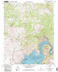
1965 Map of Millerton Lake West
USGS Topo · Published 1985About this map
The San Joaquin Experimental Range dominates the northern landscape of this region as it appeared in the mid-1960s, while the southern portion is defined by the significant reservoir behind the Friant Dam. This area represents a critical intersection of agricultural water management and research, where the Madera Canal carries water through a terrain of cattle ranches and rolling peaks like Hildreth Mountain and Hulbert Mountain. Historical footprints are visible at Bellview (Site) and the Spring Valley Sch, providing clues to earlier settlement patterns in the foothills. The map documents the development of the Millerton Lake State Recreation Area, showing popular locales such as Winchell Bay and the prominent Pincushion Mountain overlook. Throughout the quadrangle, legacy property names including the J McDougal Ranch and O'Neal Ranch indicate the enduring ranching culture of this Madera and Fresno County borderland.
Find a feature on this map
37 named features on this map. Tap any name to fly to it.
Don’t see what you’re looking for? This feature index may not catch every label — zoom into the map to look around manually.
Map Details
Editions of this 1965 Millerton Lake West Map
4 editions found
Other maps of this area

1912 · Mariposa
USGS Topo · 1:125,000

1916 · Sulphur Springs
USGS Topo · 1:24,000

1919 · Sulphur Springs
USGS Topo · 1:31,680

1919 · Little Table Mountain
USGS Topo · 1:31,680

1922 · Lanes Bridge
USGS Topo · 1:31,680

1922 · Friant
USGS Topo · 1:31,680

1923 · Academy
USGS Topo · 1:31,680

1942 · Raymond
USGS Topo · 1:62,500

1942 · Little Table Mountain
USGS Topo · 1:24,000

1942 · Millerton Lake
USGS Topo · 1:62,500