1937 Map of Millheim
USGS Topo · Published 1937About this map
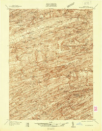
The ridge-and-valley landscape of central Pennsylvania is deeply engraved on this 1937 survey, where mountain ranges like Nittany Mountain and Jacks Mountain dictate the placement of early settlements and roads. The linear valleys host concentrated farming communities such as Aaronsburg and Millheim, while more remote pockets like Wolfs Store and Tylersville sit tucked near the base of the steep slopes. The prominence of public land is evident through the Bald Eagle State Forest and the Voneida State Forest Park, reflecting the era's conservation and recreation efforts including a designated CCC Camp.
Find a feature on this map
76 named features on this map. Tap any name to fly to it.
Don’t see what you’re looking for? This feature index may not catch every label — zoom into the map to look around manually.
Map Details
Editions of this 1937 Millheim Map
This is the sole edition of this map. No revisions or reprints were ever made.
Other maps of this area

1907 · Millerstown
USGS Topo · 1:62,500

1921 · Howard
USGS Topo · 1:48,000

1921 · Williamsport
USGS Topo · 1:48,000

1921 · Lock Haven
USGS Topo · 1:62,500

1923 · Howard
USGS Topo · 1:62,500

1923 · Lock Haven
USGS Topo · 1:62,500

1923 · Williamsport
USGS Topo · 1:62,500

1924 · Centre Hall
USGS Topo · 1:62,500

1924 · Lewistown
USGS Topo · 1:62,500

1925 · Mifflintown
USGS Topo · 1:48,000
Featured Places
- Decatur Township, PA
- Millheim, PA
- Aaronsburg, Haines Township
- Pardee, Hartley Township
- Rockville, Miles Township