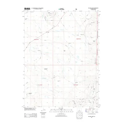
2013 Map of Milligan Lakes
USGS Topo · Published 2013About this map
Shattinger Ranch and Sheppard Ranch anchor a high-altitude landscape defined by ranching and water management in the early 21st century. The complex hydrology of the region is evident through an extensive system of man-made waterways, including the Whitten Ditch, Slater Ditch, and Randell Ditch, which divert water across the drainage divides of Michigan Cr and Tarryall Cr. These irrigation systems support various holdings such as the Slash 6 Ranch and Portis Ranch, illustrating the ongoing importance of water rights in this part of the state.
Find a feature on this map
111 named features on this map. Tap any name to fly to it.
Don’t see what you’re looking for? This feature index may not catch every label — zoom into the map to look around manually.
Map Details
Editions of this 2013 Milligan Lakes Map
This is the sole edition of this map. No revisions or reprints were ever made.
Other maps of this area

1937 · Como
USGS Topo · 1:62,500

1945 · Mount Logan
USGS Topo · 1:24,000

1948 · Mount Logan
USGS Topo · 1:24,000

1953 · Denver
USGS Topo · 1:250,000

1956 · Eagle Rock
USGS Topo · 1:24,000

1956 · Elkhorn
USGS Topo · 1:24,000

1956 · Fairplay East
USGS Topo · 1:24,000

1957 · Denver
USGS Topo · 1:250,000
1957 · Boreas Pass
USGS Topo · 1:24,000
1957 · Milligan Lakes
USGS Topo · 1:24,000