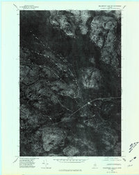
1975 Map of Millinocket Lake NE
USGS Topo · Published 1981About this map
Mooseleuk Stream snakes through a dense, forested expanse of Northern Maine in this orthophotoquad, which uses aerial photography to document the landscape of Aroostook County during the mid-1970s. The image-based format highlights the complex network of logging roads and timber harvests that define the local economy, contrasting with the untouched peaks like Middle Brook Mountain in the southern portion of the quadrangle. In the lower margins, Brown Pond sits near the base of the mountain, marking one of the few named water bodies in this heavily wooded interior. This perspective provides a clear view of the wilderness before subsequent decades of industrial forest management, preserving the exact layout of the drainage basins and ridgelines as they appeared in 1975.
Find a feature on this map
3 named features on this map. Tap any name to fly to it.
Don’t see what you’re looking for? This feature index may not catch every label — zoom into the map to look around manually.
Map Details
Editions of this 1975 Millinocket Lake NE Map
This is the sole edition of this map. No revisions or reprints were ever made.
Other maps of this area

1930 · Greenlaw
USGS Topo · 1:48,000

1931 · Mooseleuk Lake
USGS Topo · 1:48,000

1933 · Greenlaw
USGS Topo · 1:62,500

1935 · Mooseleuk Lake
USGS Topo · 1:62,500

1954 · Millinocket Lake
USGS Topo · 1:62,500

1954 · Grand Lake Seboeis
USGS Topo · 1:62,500

1954 · Presque Isle
USGS Topo · 1:250,000

1958 · Presque Isle
USGS Topo · 1:250,000

1960 · Presque Isle
USGS Topo · 1:250,000
1963 · Mooseleuk Lake
USGS Topo · 1:62,500