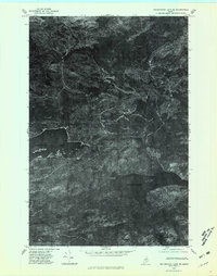
1975 Map of Millinocket Lake SE
USGS Topo · Published 1981About this map
Millinocket Lake and Millimagassett Lake dominate this orthophotoquad, which uses aerial photography from 1975 to document the northern Maine wilderness in high detail. Unlike traditional line maps, this photographic survey provides a direct view of the dense forest canopy and the complex drainage systems that define the region. The Aroostook River winds through the northern portion of the sheet, while Millinocket Stream connects the major water bodies. This specialized survey was prepared by the Geological Survey to offer a realistic perspective on the remote terrain and hydrology of the Penobscot area. Researchers and outdoorsmen can use these photographic layers to trace the historical shoreline of Big Beaver Pond and the surrounding timberlands before decades of modern forest management changed the landscape.
Find a feature on this map
5 named features on this map. Tap any name to fly to it.
Don’t see what you’re looking for? This feature index may not catch every label — zoom into the map to look around manually.
Map Details
Editions of this 1975 Millinocket Lake SE Map
This is the sole edition of this map. No revisions or reprints were ever made.
Other maps of this area

1954 · Shin Pond
USGS Topo · 1:62,500

1954 · Millinocket Lake
USGS Topo · 1:62,500

1954 · Grand Lake Seboeis
USGS Topo · 1:62,500

1954 · Presque Isle
USGS Topo · 1:250,000

1955 · Traveler Mountain
USGS Topo · 1:62,500

1958 · Presque Isle
USGS Topo · 1:250,000

1960 · Presque Isle
USGS Topo · 1:250,000
1975 · Shin Pond NW
USGS Topo · 1:24,000
1975 · Grand Lake Seboeis NW
USGS Topo · 1:24,000
1975 · Grand Lake Seboeis SW
USGS Topo · 1:24,000