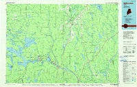
1985 Map of Millinocket
USGS Topo · Published 1986About this map
Mount Katahdin towers over the western edge of this mid-1980s planimetric survey, marking the heart of Baxter State Park. This region is defined by a complex network of waterways, from the West Branch Penobscot River feeding into Quakish Lake and Ferguson Lake, to the expansive Millinocket Lake further north. The industrial centers of Millinocket and East Millinocket are clearly detailed, showing the concentration of settlement near the river power sources that drove the local paper economy.
Find a feature on this map
266 named features on this map. Tap any name to fly to it.
Don’t see what you’re looking for? This feature index may not catch every label — zoom into the map to look around manually.
Map Details
Editions of this 1985 Millinocket Map
2 editions found
Other maps of this area

1920 · Winn
USGS Topo · 1:62,500

1927 · Katahdin
USGS Topo · 1:48,000

1930 · Katahdin
USGS Topo · 1:62,500

1931 · Springfield
USGS Topo · 1:48,000

1934 · Springfield
USGS Topo · 1:62,500

1937 · Smyrna Mills
USGS Topo · 1:62,500

1938 · Houlton
USGS Topo · 1:62,500

1940 · Danforth
USGS Topo · 1:62,500

1940 · Sebec
USGS Topo · 1:48,000

1940 · Amity
USGS Topo · 1:62,500