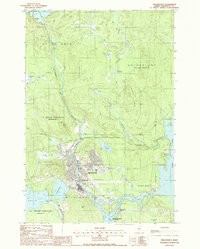
1988 Map of Millinocket
USGS Topo · Published 1988About this map
Millinocket stands as a primary hub of industrial activity and transportation in the late 1980s, shaped by the confluence of the Millinocket Stream and the West Branch Penobscot River. The town's layout reflects a dense grid of residential and commercial development, including the Little Italy neighborhood, set against a backdrop of managed waterways and utility infrastructure. Large-scale water management is evident at the Quakish Dam and the sprawling expanse of Quakish Lake, which support the region's historical reliance on river-based power and industry.
Find a feature on this map
35 named features on this map. Tap any name to fly to it.
Don’t see what you’re looking for? This feature index may not catch every label — zoom into the map to look around manually.
Map Details
Editions of this 1988 Millinocket Map
This is the sole edition of this map. No revisions or reprints were ever made.
Other maps of this area

1927 · Katahdin
USGS Topo · 1:48,000

1930 · Katahdin
USGS Topo · 1:62,500

1949 · Katahdin
USGS Topo · 1:62,500

1951 · Norcross
USGS Topo · 1:62,500

1951 · Millinocket
USGS Topo · 1:62,500

1953 · Stacyville
USGS Topo · 1:62,500

1954 · Millinocket
USGS Topo · 1:250,000

1958 · Millinocket
USGS Topo · 1:250,000

1960 · Millinocket
USGS Topo · 1:250,000

1975 · Millinocket SW
USGS Topo · 1:24,000