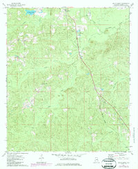
1974 Map of Millry South
USGS Topo · Published 1987About this map
The Old Indian Treaty Boundary slices across this landscape of Washington County, marking a significant historical line of demarcation that persists through the 1970s. The Burlington Northern railroad serves as the primary industrial corridor, linking the small communities of Millry, Loper, and Yarbo. This rural Alabama survey documents a transition from thick woodland and timber resources to the organized agricultural and small-town footprints of the late twentieth century. Cultural landmarks such as Barlow Chapel and the Yarbo Cemetery provide essential reference points for genealogists tracking local family histories. The terrain is defined by the convergence of the North and South Prong toward the Pine Barren Creek basin, illustrating the drainage patterns that shaped early settlement and local road networks.
Find a feature on this map
23 named features on this map. Tap any name to fly to it.
Don’t see what you’re looking for? This feature index may not catch every label — zoom into the map to look around manually.
Map Details
Editions of this 1974 Millry South Map
2 editions found
Other maps of this area

1943 · McIntosh
USGS Topo · 1:62,500

1944 · McIntosh
USGS Topo · 1:62,500

1953 · Hattiesburg
USGS Topo · 1:250,000

1958 · Hattiesburg
USGS Topo · 1:250,000

1971 · Bigbee
USGS Topo · 1:24,000

1971 · Bladon Springs
USGS Topo · 1:24,000

1974 · Millry South
USGS Topo · 1:24,000

1974 · Chatom
USGS Topo · 1:24,000

1974 · State Line
USGS Topo · 1:24,000

1974 · Millry North
USGS Topo · 1:24,000