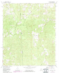
1974 Map of Copeland
USGS Topo · Published 1987About this map
The Old Indian Treaty Boundary slices diagonally across this landscape, marking a historical frontier through the pine-wooded borderlands of Alabama and Mississippi. At this time in the 1970s, the region is characterized by a network of small, rural communities and scattered houses of worship, such as Lewis Chapel and Antioch Ch. The drainage patterns are defined by the Escatawpa River and its numerous tributaries, including Little Red Creek and Big Red Creek, which feed into the swampy bottomlands. Settlement is concentrated around small hubs like Copeland and Belmont, with local industry represented by several Sandpit operations and a Gas Well. Genealogists will find notable value in the specific placement of family-named burial sites like Chason Cem and Carter Cem, providing a clear look at the area's rural social geography before later 20th-century developments.
Find a feature on this map
29 named features on this map. Tap any name to fly to it.
Don’t see what you’re looking for? This feature index may not catch every label — zoom into the map to look around manually.
Map Details
Editions of this 1974 Copeland Map
3 editions found
Other maps of this area

1953 · Hattiesburg
USGS Topo · 1:250,000

1958 · Hattiesburg
USGS Topo · 1:250,000

1964 · Denham
USGS Topo · 1:24,000

1964 · Knobtown
USGS Topo · 1:24,000

1964 · Buckatunna
USGS Topo · 1:24,000

1974 · Millry South
USGS Topo · 1:24,000

1974 · Chatom
USGS Topo · 1:24,000

1974 · State Line
USGS Topo · 1:24,000

1974 · Millry North
USGS Topo · 1:24,000

1974 · Copeland
USGS Topo · 1:24,000