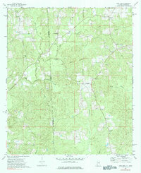
1974 Map of Copeland
USGS Topo · Published 1984About this map
The Old Indian Treaty Boundary slices diagonally across this landscape, marking a historic division that persists alongside the modern state line between Alabama and Mississippi. This mid-1970s survey centered on Copeland reveals a rural territory defined by the winding course of the Escatawpa River and its tributaries, including Little Red Creek and Crosbys Creek. Settlement patterns are anchored by numerous small congregations and family burial grounds, such as Zion Rest Ch and the Carter Cem. The presence of several sandpits and a Gas Well south of the main settlement indicates the local extraction economy of the era. Genealogists will find a dense network of local landmarks, from Lewis Chapel in the north to New Haven Ch in the south, reflecting the established community nodes of Washington County.
Find a feature on this map
29 named features on this map. Tap any name to fly to it.
Don’t see what you’re looking for? This feature index may not catch every label — zoom into the map to look around manually.
Map Details
Editions of this 1974 Copeland Map
3 editions found
Other maps of this area

1953 · Hattiesburg
USGS Topo · 1:250,000

1958 · Hattiesburg
USGS Topo · 1:250,000

1964 · Denham
USGS Topo · 1:24,000

1964 · Knobtown
USGS Topo · 1:24,000

1964 · Buckatunna
USGS Topo · 1:24,000

1974 · Millry South
USGS Topo · 1:24,000

1974 · Chatom
USGS Topo · 1:24,000

1974 · State Line
USGS Topo · 1:24,000

1974 · Millry North
USGS Topo · 1:24,000

1974 · Copeland
USGS Topo · 1:24,000