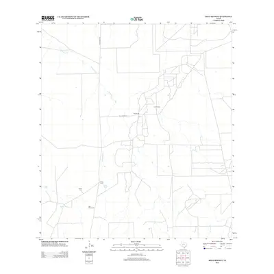
2013 Map of Mills Bennett
USGS Topo · Published 2013About this map
Mills Bennett and the surrounding ranching landscape of Webb County are defined by a network of drainage creeks and isolated family landmarks. The landscape is dominated by the winding path of Mesquitoso Cr and Parrilla Cr, which are supported by several essential water catchments such as Charo Tank, Home Tank, and Middle Tank. This 2013 survey illustrates the continued reliance on these features in a semi-arid region where water and oil define land use. Evidence of the area's industrial activity is centered at the Lopez Oil Field, while local genealogy is rooted at the Billings Cem near the Billings Ranch. Transportation across this section of South Texas is facilitated by Ranch Road 2050 and Mills Bennett Rd, connecting the dispersed settlements of Las Hermanas and Mills Bennett to the broader regional grid.
Find a feature on this map
12 named features on this map. Tap any name to fly to it.
Don’t see what you’re looking for? This feature index may not catch every label — zoom into the map to look around manually.
Map Details
Editions of this 2013 Mills Bennett Map
This is the sole edition of this map. No revisions or reprints were ever made.
Other maps of this area

1956 · Freer
USGS Topo · 1:62,500

1956 · Las Mujeres
USGS Topo · 1:62,500

1956 · Laredo
USGS Topo · 1:250,000

1968 · Parrilla Creek SW
USGS Topo · 1:24,000
1968 · Mills Bennett SW
USGS Topo · 1:24,000

1968 · Mills Bennett
USGS Topo · 1:24,000

1968 · Parrilla Creek NW
USGS Topo · 1:24,000

1968 · Mills Bennett NW
USGS Topo · 1:24,000

1968 · San Pablo
USGS Topo · 1:24,000
1971 · Sarnosa Hill
USGS Topo · 1:24,000