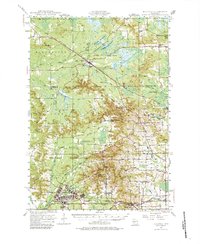
1947 Map of Millston
USGS Topo · Published 1983About this map
Camp McCoy Military Reservation dominates the southern half of this landscape, sprawling across the Jackson and Monroe county line during the post-war era. The survey captures a transition from the structured military grounds at Camp McCoy to the wetland-rich terrain of the north, where the Shaptail Flowage and Pigeon Creek Flowage dictate the local geography. Significant rail infrastructure, including the Chicago and North Western and Minneapolis St Paul and Sault Ste Marie lines, connects the small village of Millston to outlying communities like Warrens and Tunnel City. Rural education is well-represented through numerous landmark schoolhouses such as Drescher Sch and Paradise Sch, while the Oak Ridge Fire Tower stands as a sentinel over the western forests. This map provides a detailed view of the regional hydrological network, from Robinson Creek to the La Crosse River, at a time when the military presence was becoming a permanent fixture of the central Wisconsin landscape.
Find a feature on this map
58 named features on this map. Tap any name to fly to it.
Don’t see what you’re looking for? This feature index may not catch every label — zoom into the map to look around manually.
Map Details
Editions of this 1947 Millston Map
4 editions found
Other maps of this area

1909 · Sparta
USGS Topo · 1:62,500

1916 · Tomah
USGS Topo · 1:62,500

1919 · Kendall
USGS Topo · 1:62,500

1921 · Kendall
USGS Topo · 1:62,500

1924 · Black River Falls
USGS Topo · 1:62,500

1926 · Black River Falls
USGS Topo · 1:62,500

1928 · Melrose
USGS Topo · 1:48,000

1947 · Millston
USGS Topo · 1:62,500

1947 · Sparta
USGS Topo · 1:62,500

1949 · Millston
USGS Topo · 1:62,500