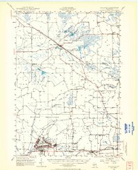
1947 Map of Millston
USGS Topo · Published 1966About this map
Camp McCoy Military Reservation dominates the southwestern quadrant of this landscape, its structured grid of barracks and training grounds at Camp McCoy providing a stark contrast to the surrounding marshlands and glacial topography. This mid-century environment is defined by extensive cranberry bogs and flowages, such as the Skunkhill Flowage and Pigeon Creek Flowage, which supported the local agricultural economy. The transportation network is anchored by the St Paul Minneapolis and Omaha and Chicago and North Western railroads, which facilitated the movement of goods through small whistle-stops like Millston and Warrens. The map details a rural social fabric of the late 1940s, marked by numerous small schoolhouses like Drescher Sch and Paradise Sch, as well as the St Marys Ch in the village of Tunnel City. Scattered fire towers, including Oak Ridge Fire Tower and Knapp Mound Fire Tower, overlook a terrain shaped by the La Crosse River and its many winding tributaries.
Find a feature on this map
58 named features on this map. Tap any name to fly to it.
Don’t see what you’re looking for? This feature index may not catch every label — zoom into the map to look around manually.
Map Details
Editions of this 1947 Millston Map
4 editions found
Other maps of this area

1909 · Sparta
USGS Topo · 1:62,500

1916 · Tomah
USGS Topo · 1:62,500

1919 · Kendall
USGS Topo · 1:62,500

1921 · Kendall
USGS Topo · 1:62,500

1924 · Black River Falls
USGS Topo · 1:62,500

1926 · Black River Falls
USGS Topo · 1:62,500

1928 · Melrose
USGS Topo · 1:48,000

1947 · Millston
USGS Topo · 1:62,500

1947 · Sparta
USGS Topo · 1:62,500

1949 · Millston
USGS Topo · 1:62,500