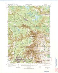
1947 Map of Millston
USGS Topo · Published 1966About this map
Camp McCoy Military Reservation dominates the southern landscape of this 1940s survey, showing the barracks and grid of Camp McCoy just before it became a major Cold War training site. The map documents a rural economy tied to the land, where numerous Cranberry Bogs dot the lowlands between Millston and Warrens. This unique hydrologic environment is fed by Pigeon Creek Flowage and Sharprail Flowage, while the Chicago St Paul Minneapolis and Omaha railroad provides the primary transport artery through the marshy terrain. Local community life is evidenced by a dense network of country schools, including Oakdale Sch, Summit Valley Sch, and White Sch. Significant topographic landmarks such as Castle Rock, Knapp Mound, and the Rudes Hills provide vertical relief against the winding La Crosse River.
Find a feature on this map
51 named features on this map. Tap any name to fly to it.
Don’t see what you’re looking for? This feature index may not catch every label — zoom into the map to look around manually.
Map Details
Editions of this 1947 Millston Map
4 editions found
Other maps of this area

1909 · Sparta
USGS Topo · 1:62,500

1916 · Tomah
USGS Topo · 1:62,500

1919 · Kendall
USGS Topo · 1:62,500

1921 · Kendall
USGS Topo · 1:62,500

1924 · Black River Falls
USGS Topo · 1:62,500

1926 · Black River Falls
USGS Topo · 1:62,500

1928 · Melrose
USGS Topo · 1:48,000

1947 · Millston
USGS Topo · 1:62,500

1947 · Sparta
USGS Topo · 1:62,500

1949 · Millston
USGS Topo · 1:62,500