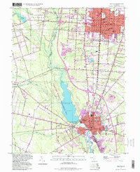
1997 Map of Millville
USGS Topo · Published 1998About this map
The Maurice River corridor defines the landscape of this southern New Jersey survey, anchoring the industrial and residential hub of Millville. At the heart of the region, the expansive Union Lake and its surrounding Union Lake Wildlife Management Area create a significant natural break between the dense urban grid of Vineland to the northeast and the outlying agricultural areas. The map reveals a high concentration of institutional and community landmarks, particularly near the Vineland city line where the State Hospital, Newcomb Hospital, and numerous parochial schools like Sacred Heart Sch are clustered.
Find a feature on this map
62 named features on this map. Tap any name to fly to it.
Don’t see what you’re looking for? This feature index may not catch every label — zoom into the map to look around manually.
Map Details
Editions of this 1997 Millville Map
This is the sole edition of this map. No revisions or reprints were ever made.
Other maps of this area

1890 · Hammonton
USGS Topo · 1:62,500

1890 · Tuckahoe
USGS Topo · 1:62,500

1890 · Bridgeton
USGS Topo · 1:62,500

1890 · Glassboro
USGS Topo · 1:62,500

1893 · Tuckahoe
USGS Topo · 1:62,500

1894 · Hammonton
USGS Topo · 1:62,500

1894 · Bridgeton
USGS Topo · 1:62,500

1898 · Glassboro
USGS Topo · 1:62,500

1898 · Hammonton
USGS Topo · 1:62,500

1899 · Vineland
USGS Topo · 1:125,000