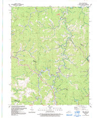
1992 Map of Milo
USGS Topo · Published 1992About this map
Rockcastle Creek and the Tug Fork define the movement of life through this portion of Martin and Lawrence Counties. The terrain is characterized by a dense network of hollows and ridges, where small settlements like Milo and Stidham are situated near the confluence of local forks. Evidence of the region's energy and infrastructure history is visible through the Strip Mine operations and a network of gas pipelines and wells. Local community life is anchored by numerous small houses of worship, including New Friendship Ch, Favored Ch, and Kirk Memorial Ch. Near the center of the sheet, Martin County Lake serves as a significant water feature, while the Grassy Sch and various cemeteries offer valuable points of interest for those tracing the social fabric of these mountain communities in the early 1990s.
Find a feature on this map
98 named features on this map. Tap any name to fly to it.
Don’t see what you’re looking for? This feature index may not catch every label — zoom into the map to look around manually.
Map Details
Editions of this 1992 Milo Map
This is the sole edition of this map. No revisions or reprints were ever made.
Other maps of this area

1886 · Prestonsburg
USGS Topo · 1:125,000

1887 · Warfield
USGS Topo · 1:125,000

1891 · Warfield
USGS Topo · 1:125,000

1892 · Prestonsburg
USGS Topo · 1:125,000

1892 · Huntington
USGS Topo · 1:125,000

1898 · Huntington
USGS Topo · 1:125,000

1903 · Kenova
USGS Topo · 1:125,000

1904 · Kenova
USGS Topo · 1:125,000

1909 · Wayne
USGS Topo · 1:62,500

1910 · Naugatuck
USGS Topo · 1:48,000