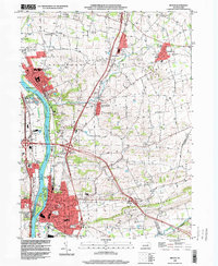
1998 Map of Milton
USGS Topo · Published 2000About this map
The West Branch Susquehanna River serves as the central artery for this late-1990s landscape, bordering the industrial and residential hub of Milton. The town’s dense grid is flanked by Milton State Park on an island in the river, reflecting a transition from purely industrial river use to public recreation. Inland, the terrain is defined by Limestone Ridge and several distinct boroughs, including Watsontown, Turbotville, and McEwensville. For genealogists, the map is remarkably dense with burial sites such as Milton Cemetery, Harmony Cemetery, and Old Cem, alongside numerous country churches like Messiah Ch. The agricultural and small-town character of Northumberland County remains evident in the numerous Gravel Pits and the sprawling municipal boundaries of Delaware and West Chillisquaque townships.
Find a feature on this map
51 named features on this map. Tap any name to fly to it.
Don’t see what you’re looking for? This feature index may not catch every label — zoom into the map to look around manually.
Map Details
Editions of this 1998 Milton Map
This is the sole edition of this map. No revisions or reprints were ever made.
Other maps of this area

1892 · Shamokin
USGS Topo · 1:62,500

1893 · Sunbury
USGS Topo · 1:62,500

1893 · Shamokin
USGS Topo · 1:62,500

1924 · Milton
USGS Topo · 1:62,500

1935 · Hughesville
USGS Topo · 1:62,500

1943 · Shamokin
USGS Topo · 1:62,500

1943 · Sunbury
USGS Topo · 1:62,500

1950 · Harrisburg
USGS Topo · 1:250,000

1952 · Shamokin
USGS Topo · 1:62,500

1953 · Hughesville
USGS Topo · 1:62,500