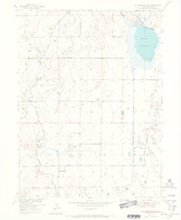
1951 Map of Milton Reservoir
USGS Topo · Published 1965About this map
Milton Reservoir dominates the northeastern corner of this Weld County landscape, serving as a vital hub for a sophisticated network of irrigation infrastructure. This post-war era survey, compiled as part of the Missouri River Basin development program, illustrates the critical role of water management in Colorado's high plains. A complex system of waterways, including the Platteville Lateral Canal, West Speer Canal, and East Speer Canal, crisscross the terrain to support local agriculture. The social and industrial fabric of the community is evidenced by the centrally located Four-Way School and an Inactive Coal Mine to the west, signaling a shift in the local economy from mineral extraction toward managed cultivation. Numerous windmills are scattered throughout the sections, highlighting the ongoing reliance on groundwater alongside the more modern seep canals like Beebe Seep Canal and Bowles Seep Canal.
Find a feature on this map
11 named features on this map. Tap any name to fly to it.
Don’t see what you’re looking for? This feature index may not catch every label — zoom into the map to look around manually.
Map Details
Editions of this 1951 Milton Reservoir Map
2 editions found
Other maps of this area

1902 · Greeley
USGS Topo · 1:125,000

1949 · Fort Lupton
USGS Topo · 1:24,000

1949 · Platteville
USGS Topo · 1:24,000

1949 · Hudson
USGS Topo · 1:24,000

1950 · Platteville
USGS Topo · 1:24,000
1950 · Fort Lupton
USGS Topo · 1:24,000

1950 · Keenesburg
USGS Topo · 1:24,000

1950 · Milliken
USGS Topo · 1:24,000

1950 · Klug Ranch
USGS Topo · 1:24,000

1950 · Valley View School
USGS Topo · 1:24,000