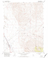
1967 Map of Mina
USGS Topo · Published 1984About this map
Mina serves as the focal point for this survey of the Nevada desert, positioned at the foot of the Gabbs Valley Range. In the late 1960s, the town's character was defined by its relationship with the Southern Pacific railroad, which runs parallel to an Old Railroad Grade and an extensive Aqueduct. The landscape transitions from the Alkali Flat and Soda Spring Valley in the west to the steep slopes of the Pilot Mountains in the southeast. Evidence of the region's mineral history is visible through features like the Nun Mine in New York Canyon and the Pine Tree Mine near the southern boundary. Essential water sources such as the Southern Pacific Spring and various Springs in Water Canyon supported life and industry in this arid environment.
Find a feature on this map
33 named features on this map. Tap any name to fly to it.
Don’t see what you’re looking for? This feature index may not catch every label — zoom into the map to look around manually.
Map Details
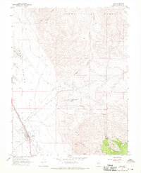
Editions of this 1967 Mina Map
2 editions found
Other maps of this area

1907 · Tonopah
USGS Topo · 1:250,000

1908 · Tonopah
USGS Topo · 1:250,000

1909 · Hawthorne
USGS Topo · 1:250,000

1911 · Hawthorne
USGS Topo · 1:250,000

1915 · Hawthorne
USGS Topo · 1:250,000

1948 · Walker Lake
USGS Topo · 1:250,000

1956 · Tonopah
USGS Topo · 1:250,000

1957 · Walker Lake
USGS Topo · 1:250,000

1959 · Tonopah
USGS Topo · 1:250,000

1962 · Walker Lake
USGS Topo · 1:250,000