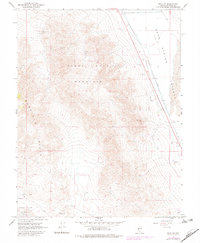
1967 Map of Mina NW
USGS Topo · Published 1982About this map
Black Dyke Mountain and the Garfield Hills dominate this section of Mineral County, illustrating a landscape defined by Great Basin mining activity and high-desert basins. The map captures a network of small-scale operations including the Windup Mine, Blue Ribbon Mine, Jeep Mine, and Kay Mine, many of which are accessed by a rugged Jeep Trail winding through the uplands. Along the eastern edge, the Southern Pacific railroad runs parallel to the arid expanse of Soda Spring Valley, where Sand Dunes and the Alkali Flat indicate the endorheic nature of the local hydrology. This 1967 survey, with 1982 photorevisions, provides a precise record of the extraction infrastructure and transport corridors that sustained these remote Nevada districts.
Find a feature on this map
16 named features on this map. Tap any name to fly to it.
Don’t see what you’re looking for? This feature index may not catch every label — zoom into the map to look around manually.
Map Details
Editions of this 1967 Mina NW Map
3 editions found
Other maps of this area

1909 · Hawthorne
USGS Topo · 1:250,000

1911 · Hawthorne
USGS Topo · 1:250,000

1915 · Hawthorne
USGS Topo · 1:250,000

1948 · Walker Lake
USGS Topo · 1:250,000

1957 · Walker Lake
USGS Topo · 1:250,000

1962 · Walker Lake
USGS Topo · 1:250,000

1964 · Walker Lake
USGS Topo · 1:250,000

1967 · Moho Mountain
USGS Topo · 1:24,000

1967 · Mina NW
USGS Topo · 1:24,000
1967 · Sodaville
USGS Topo · 1:24,000