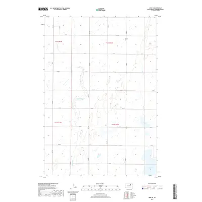
2017 Map of Mina SE
USGS Topo · Published 2017About this map
The prairie landscape of Edmunds County reveals a complex network of seasonal waterways and glacial basins, dominated by the winding course of Preachers Run. This drainage system flows southward through a series of shallow depressions, eventually meeting the larger basins of Grass Lake and N Scatterwood Lake in the southeast corner. The land is defined by the rigid grid of the Public Land Survey System, with gravel roads like 366th Ave and Co Rd 15 marking section lines across the townships. Cultural history is anchored by the Richland Cem in the northeastern reaches, providing a vital point of reference for genealogists tracking early families in this rural expanse. Apart from the cemetery, the map shows a landscape largely devoted to agricultural use, with intermittent wetlands and the intermittent flow of Stony Run creating a distinct pattern of land use around the permanent water bodies.
Find a feature on this map
23 named features on this map. Tap any name to fly to it.
Don’t see what you’re looking for? This feature index may not catch every label — zoom into the map to look around manually.
Map Details
Editions of this 2017 Mina SE Map
This is the sole edition of this map. No revisions or reprints were ever made.
Other maps of this area

1899 · Northville
USGS Topo · 1:125,000

1954 · Aberdeen
USGS Topo · 1:250,000

1956 · Aberdeen
USGS Topo · 1:250,000
1966 · Chelsea
USGS Topo · 1:24,000
1966 · Cresbard NE
USGS Topo · 1:24,000

1966 · Cresbard
USGS Topo · 1:24,000

1970 · Lake Parmley
USGS Topo · 1:24,000

1970 · Mina SW
USGS Topo · 1:24,000
1970 · Lake Parmley SW
USGS Topo · 1:24,000

1970 · Mina NW
USGS Topo · 1:24,000