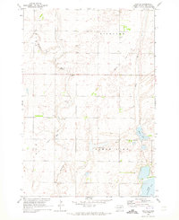
1970 Map of Mina SE
USGS Topo · Published 1973About this map
Richland and Clear Lake townships define this rural landscape in Edmunds County during the early 1970s. The area is characterized by its glacial prairie potholes and drainage systems, with Preachers Run and Stony Run cutting through the terrain toward Grass Lake. This 1970 survey captures a specific moment of rural infrastructure, showing the Old Railroad Grade as a prominent diagonal marker across the plains, reflecting a shift in regional transportation and land use. Local community centers are anchored by the Richland Ch and Richland Cem, while a standalone Townhall sits near the eastern edge of Clear Lake township. Scattered Gravel Pits and a Flowing Well suggest the local reliance on both the geology and the groundwater of the plains during this era.
Find a feature on this map
14 named features on this map. Tap any name to fly to it.
Don’t see what you’re looking for? This feature index may not catch every label — zoom into the map to look around manually.
Map Details
Editions of this 1970 Mina SE Map
This is the sole edition of this map. No revisions or reprints were ever made.
Other maps of this area

1899 · Northville
USGS Topo · 1:125,000

1954 · Aberdeen
USGS Topo · 1:250,000

1956 · Aberdeen
USGS Topo · 1:250,000
1966 · Chelsea
USGS Topo · 1:24,000
1966 · Cresbard NE
USGS Topo · 1:24,000

1966 · Cresbard
USGS Topo · 1:24,000

1970 · Lake Parmley
USGS Topo · 1:24,000

1970 · Mina SW
USGS Topo · 1:24,000
1970 · Lake Parmley SW
USGS Topo · 1:24,000

1970 · Mina NW
USGS Topo · 1:24,000