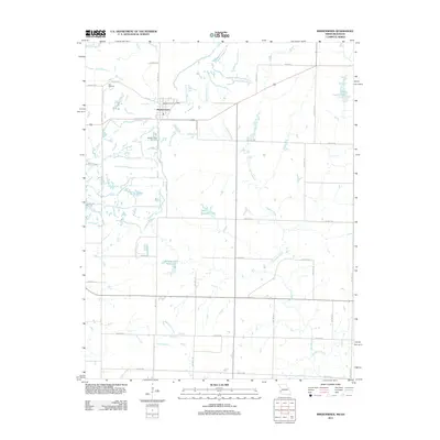
2011 Map of Mindenmines
USGS Topo · Published 2011About this map
Mindenmines sits at the heart of this landscape in Barton County, Missouri, positioned just east of the Kansas border marked by State Line Rd. The town's civic identity is anchored by the Mindenmines Post Office and the nearby Mindenmines Cemetery, while the Yale Cemetery lies further west. The surrounding countryside is defined by an intricate network of waterways, including the meandering Glendale Fork and the Blackberry Creek drainage system. Several significant water bodies dot the terrain, such as the Number 180 Reservoir, John Gardner Lake, and Finley Lake. The map reveals a highly structured grid of rural routes like SW 80th Rd and SW 160th Ln, reflecting the organized agricultural and land-management patterns typical of this Missouri-Kansas border region in the early twenty-first century.
Find a feature on this map
32 named features on this map. Tap any name to fly to it.
Don’t see what you’re looking for? This feature index may not catch every label — zoom into the map to look around manually.
Map Details
Editions of this 2011 Mindenmines Map
This is the sole edition of this map. No revisions or reprints were ever made.
Other maps of this area

1884 · Fort Scott
USGS Topo · 1:125,000

1886 · Nevada
USGS Topo · 1:125,000

1886 · Joplin
USGS Topo · 1:125,000

1886 · Fort Scott
USGS Topo · 1:125,000

1886 · Carthage
USGS Topo · 1:125,000

1893 · Fort Scott
USGS Topo · 1:125,000

1894 · Nevada
USGS Topo · 1:125,000

1894 · Joplin
USGS Topo · 1:125,000

1894 · Carthage
USGS Topo · 1:125,000

1945 · Pittsburg
USGS Topo · 1:62,500