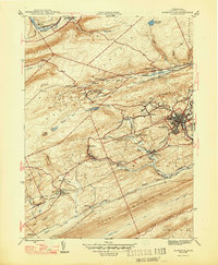
1947 Map of Minersville
USGS Topo · Published 1947About this map
Minersville serves as the industrial and population hub of this anthracite-rich region, where the steep ridges of Sharp Mountain and Second Mountain dictate the flow of commerce. The 1940s landscape is defined by the heavy infrastructure of the Reading and Pennsylvania railroads, which weave through narrow gaps to service numerous mining operations. These transport lines connect a dense network of specialized settlements including Heckscherville, Glen Carbon, and Coal Castle, each tied to the local extraction economy.
Find a feature on this map
57 named features on this map. Tap any name to fly to it.
Don’t see what you’re looking for? This feature index may not catch every label — zoom into the map to look around manually.
Map Details
Editions of this 1947 Minersville Map
2 editions found
Other maps of this area

1889 · Catawissa
USGS Topo · 1:62,500

1889 · Pottsville
USGS Topo · 1:62,500

1891 · Pottsville
USGS Topo · 1:62,500

1892 · Catawissa
USGS Topo · 1:62,500

1892 · Mahanoy
USGS Topo · 1:62,500

1892 · Pine Grove
USGS Topo · 1:62,500

1893 · Mahanoy
USGS Topo · 1:62,500

1894 · Catawissa
USGS Topo · 1:62,500

1944 · Pottsville
USGS Topo · 1:24,000

1945 · Friedensburg
USGS Topo · 1:24,000