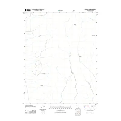
2012 Map of Minerva Canyon
USGS Topo · Published 2012About this map
Highland Ridge dominates this high-altitude landscape in White Pine County, where a network of dry washes and deep canyons defines the drainage patterns of the eastern Great Basin. Critical water sources in this arid environment are identified at Mustang Spring and Decathon Spring, serving as vital landmarks for those traversing the high country. The map traces the rugged path of Johns Wash as it cuts through the center of the quadrangle, flanked by numerous named drainages such as Minerva Canyon, Silver Chief Canyon, and Lincoln Canyon.
Find a feature on this map
14 named features on this map. Tap any name to fly to it.
Don’t see what you’re looking for? This feature index may not catch every label — zoom into the map to look around manually.
Map Details
Editions of this 2012 Minerva Canyon Map
This is the sole edition of this map. No revisions or reprints were ever made.
Other maps of this area

1948 · Wheeler Peak
USGS Topo · 1:62,500

1949 · Garrison
USGS Topo · 1:62,500

1950 · Wheeler Peak
USGS Topo · 1:62,500

1951 · Garrison
USGS Topo · 1:62,500

1956 · Lund
USGS Topo · 1:250,000

1960 · Lund
USGS Topo · 1:250,000

1972 · Big Springs
USGS Topo · 1:24,000

1973 · Indian Springs Knolls
USGS Topo · 1:24,000

1973 · Red Ledges
USGS Topo · 1:24,000
1979 · Garrison
USGS Topo · 1:100,000