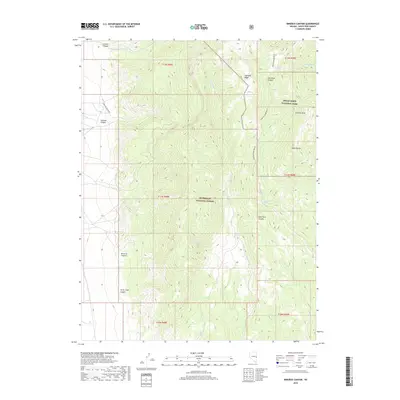
2018 Map of Minerva Canyon
USGS Topo · Published 2018About this map
Humboldt National Forest and Great Basin National Park dominate this high-altitude landscape in the Snake Range of eastern Nevada. The terrain is defined by extreme vertical relief, rising from the floors of Minerva Canyon and Silver Chief Canyon to the prominent summit of Granite Peak. The mapping of this area focuses heavily on the drainage systems and seasonal water sources vital to this arid environment, including Mustang Spring, Decathon Spring, and the long descent of Johns Wash. Access is limited to primitive paths like the Highland Ridge Route and Swallow Canyon Rd, reflecting a wilderness character preserved within federal lands. The transition between national forest and national park boundaries highlights the protected status of the Highland Ridge area, where geological features like Swallow Canyon remain largely untouched by modern development.
Find a feature on this map
24 named features on this map. Tap any name to fly to it.
Don’t see what you’re looking for? This feature index may not catch every label — zoom into the map to look around manually.
Map Details
Editions of this 2018 Minerva Canyon Map
This is the sole edition of this map. No revisions or reprints were ever made.
Other maps of this area

1948 · Wheeler Peak
USGS Topo · 1:62,500

1949 · Garrison
USGS Topo · 1:62,500

1950 · Wheeler Peak
USGS Topo · 1:62,500

1951 · Garrison
USGS Topo · 1:62,500

1956 · Lund
USGS Topo · 1:250,000

1960 · Lund
USGS Topo · 1:250,000

1972 · Big Springs
USGS Topo · 1:24,000

1973 · Indian Springs Knolls
USGS Topo · 1:24,000

1973 · Red Ledges
USGS Topo · 1:24,000
1979 · Garrison
USGS Topo · 1:100,000