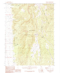
1987 Map of Minerva Canyon
USGS Topo · Published 1987About this map
Humboldt National Forest and the western edge of Great Basin National Park define this high-altitude landscape in the Snake Range. The map reveals an intensive history of mineral extraction concentrated along the slopes of Minerva Canyon, where a network of 4WD tracks connects operations like the Tungsten Queen Mine, Everett Mines, and The Chief Mine. These sites indicate the area's mid-20th-century importance for tungsten and silver mining, long before its designation for federal protection. Steep drainages such as Lincoln Canyon and Johns Wash flow through the dramatic relief near Highland Ridge, while unique geological features like the Natural Arch and Granite Peak punctuate the high-country terrain. This provisional edition provides a specialized look at the industrial and natural geography of White Pine County shortly after the creation of the national park.
Find a feature on this map
30 named features on this map. Tap any name to fly to it.
Don’t see what you’re looking for? This feature index may not catch every label — zoom into the map to look around manually.
Map Details
Editions of this 1987 Minerva Canyon Map
This is the sole edition of this map. No revisions or reprints were ever made.
Other maps of this area

1948 · Wheeler Peak
USGS Topo · 1:62,500

1949 · Garrison
USGS Topo · 1:62,500

1950 · Wheeler Peak
USGS Topo · 1:62,500

1951 · Garrison
USGS Topo · 1:62,500

1956 · Lund
USGS Topo · 1:250,000

1960 · Lund
USGS Topo · 1:250,000

1972 · Big Springs
USGS Topo · 1:24,000

1973 · Indian Springs Knolls
USGS Topo · 1:24,000

1973 · Red Ledges
USGS Topo · 1:24,000
1979 · Garrison
USGS Topo · 1:100,000