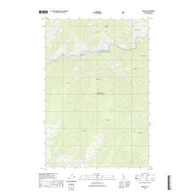
2020 Map of Mink Peak
USGS Topo · Published 2020About this map
The Middle Fork Clearwater Wild and Scenic River carves a deep path through the protected wilderness of the Nez Perce National Forest in this 2020 survey. This area of Idaho County is defined by its dramatic verticality, where high-altitude landmarks like Mink Peak and Wolf Point look down upon the river canyon below. Significant water features such as Doe Lake and the thermal waters of Morten Hot Springs are situated in a landscape largely untouched by modern infrastructure. The map documents the intricate drainage network of the Clearwater River system, including Three Links Cr and Marten Cr. Key topographic formations like Sixtytwo Ridge and Dry Bar illustrate the geological forces at work, providing a detailed record for those studying the remote interior of the Idaho panhandle.
Find a feature on this map
29 named features on this map. Tap any name to fly to it.
Don’t see what you’re looking for? This feature index may not catch every label — zoom into the map to look around manually.
Map Details
Editions of this 2020 Mink Peak Map
This is the sole edition of this map. No revisions or reprints were ever made.
Other maps of this area

1911 · Lolo
USGS Topo · 1:250,000

1913 · Lolo
USGS Topo · 1:250,000

1956 · Elk City
USGS Topo · 1:250,000

1956 · Hamilton
USGS Topo · 1:250,000

1959 · Hamilton
USGS Topo · 1:250,000

1960 · Elk City
USGS Topo · 1:250,000

1960 · Hamilton
USGS Topo · 1:250,000

1964 · Hamilton
USGS Topo · 1:250,000

1966 · Moose Ridge
USGS Topo · 1:24,000
1966 · Wylies Peak
USGS Topo · 1:24,000