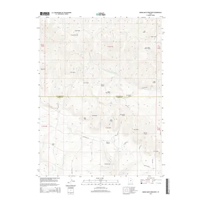
2014 Map of Minnie Maud Creek West
USGS Topo · Published 2014About this map
Roan Cliffs and Argyle Ridge define the complex geography of this high-elevation landscape along the boundary of Duchesne and Carbon counties. This 2014 survey reveals a network of canyons and ridges dissected by watercourses like Minnie Maud Cr and Summit Creek. The map documents high-country landmarks such as Orson Bedground and the broad expanse of Whitmore Park, illustrating how the terrain dictated early route-finding. Remote outposts and localities like Emma Park are connected by a system of primitive and secondary roads, including Pole Canyon Rd and Brook Meadows Rd, which follow the natural contours of the drainages. Genealogists and local historians can trace the transition from narrow canyons like Maynard Canyon to the more open meadows of Brook Meadow, providing a detailed view of this isolated section of the Uinta Basin's southern rim.
Find a feature on this map
45 named features on this map. Tap any name to fly to it.
Don’t see what you’re looking for? This feature index may not catch every label — zoom into the map to look around manually.
Map Details
Editions of this 2014 Minnie Maud Creek West Map
This is the sole edition of this map. No revisions or reprints were ever made.
Other maps of this area

1886 · Price River
USGS Topo · 1:250,000

1896 · Price River
USGS Topo · 1:250,000

1914 · Castle Gate
USGS Topo · 1:62,500

1915 · Wellington
USGS Topo · 1:62,500

1916 · Castle Gate
USGS Topo · 1:62,500

1956 · Price
USGS Topo · 1:250,000

1960 · Price
USGS Topo · 1:250,000

1962 · Price
USGS Topo · 1:250,000
1968 · Lance Canyon
USGS Topo · 1:24,000
1968 · Jones Hollow
USGS Topo · 1:24,000