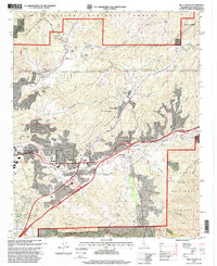
1995 Map of Mint Canyon
USGS Topo · Published 1999About this map
The Santa Clara River valley serves as the primary corridor for development and transit in this 1990s revision, where the Sierra Highway and Antelope Valley Freeway intersect at Solemint Junction. The landscape is defined by the sharp contrast between the dense residential expansion in Honby and Solemint and the protected mountainous terrain of the Angeles National Forest. Small settlements like Humphreys and Mint Canyon are situated along the valley floors, while the southern reaches of the map highlight the Placerita Canyon State Park and the Placerita Nature Center. Numerous canyons, including Bouquet Canyon and Tick Canyon, reveal a complex network of ridgelines and intermittent drainages. Evidence of the area's mixed land use appears through features such as the Sulphur Spring Sch. and a Strip Mine located east of Sand Canyon.
Find a feature on this map
39 named features on this map. Tap any name to fly to it.
Don’t see what you’re looking for? This feature index may not catch every label — zoom into the map to look around manually.
Map Details
Editions of this 1995 Mint Canyon Map
This is the sole edition of this map. No revisions or reprints were ever made.
Other maps of this area

1900 · Fernando
USGS Topo · 1:62,500

1901 · Southern California Sheet No. 1
USGS Topo · 1:250,000

1903 · Tejon
USGS Topo · 1:125,000

1903 · Camulos
USGS Topo · 1:125,000

1903 · Santa Susana
USGS Topo · 1:62,500

1904 · Southern California Sheet No. 1
USGS Topo · 1:250,000

1915 · Elizabeth Lake
USGS Topo · 1:125,000

1917 · Elizabeth Lake
USGS Topo · 1:125,000

1925 · Sylmar
USGS Topo · 1:24,000

1928 · Sylmar
USGS Topo · 1:24,000