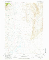
1981 Map of Miranda Flat
USGS Topo · Published 1981About this map
Mann Lake Ranch anchors the northwestern corner of this high-desert landscape in Harney County, illustrating the sparse but vital human footprint in this part of Oregon during the early 1980s. The terrain is dominated by the expansive Miranda Flat and the deep Depression to the south, highlighting a topography shaped by interior drainage and seasonal water flow. A network of ephemeral streams, including Castle Rock Creek, Little McCoy Creek, and Mosquito Creek, descends from the eastern heights toward the flatlands.
Find a feature on this map
27 named features on this map. Tap any name to fly to it.
Don’t see what you’re looking for? This feature index may not catch every label — zoom into the map to look around manually.
Map Details
Editions of this 1981 Miranda Flat Map
This is the sole edition of this map. No revisions or reprints were ever made.
Other maps of this area

1955 · Adel
USGS Topo · 1:250,000

1957 · Adel
USGS Topo · 1:250,000

1958 · Adel
USGS Topo · 1:250,000

1962 · Adel
USGS Topo · 1:250,000

1968 · Wildhorse Lake
USGS Topo · 1:24,000

1968 · Big Pasture Creek
USGS Topo · 1:24,000

1968 · Alvord Hot Springs
USGS Topo · 1:24,000
1981 · Mann Lake
USGS Topo · 1:24,000

1981 · Miranda Flat SW
USGS Topo · 1:24,000

1981 · Miranda Flat SE
USGS Topo · 1:24,000