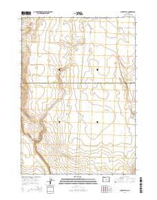
2014 Map of Misery Flat
USGS Topo · Published 2014About this map
Misery Flat and the surrounding high desert plateau characterize this area of central Oregon along the border of Crook and Deschutes counties. The landscape is defined by the winding course of the S Fork Crooked River which cuts through the volcanic terrain, carving deep contours into the earth. Evidence of the region’s hydraulic history is visible in the seasonal drainage of Buck Cr and several dry lake beds or sinks scattered across the flats. This 2014 survey documents a land primarily used for range and grazing, where the sparse network of gravel roads like Glass Butte Rd and SE GI Rd provides the only access through the vast public and private landholdings. The terrain transitions from the open expanses of the quadrangle's namesake flat into the increasingly complex ridges and draws of the surrounding high desert topography.
Find a feature on this map
1 named feature on this map. Tap any name to fly to it.
Don’t see what you’re looking for? This feature index may not catch every label — zoom into the map to look around manually.
Map Details
Editions of this 2014 Misery Flat Map
This is the sole edition of this map. No revisions or reprints were ever made.
Other maps of this area

1955 · Crescent
USGS Topo · 1:250,000

1955 · Burns
USGS Topo · 1:250,000

1957 · Crescent
USGS Topo · 1:250,000

1958 · Crescent
USGS Topo · 1:250,000

1958 · Burns
USGS Topo · 1:250,000

1959 · Burns
USGS Topo · 1:250,000

1970 · Crescent
USGS Topo · 1:250,000

1981 · Hat Butte
USGS Topo · 1:24,000
1981 · Dust Bowl
USGS Topo · 1:24,000
1981 · Ibex Butte
USGS Topo · 1:24,000