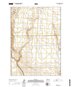
2020 Map of Misery Flat
USGS Topo · Published 2020About this map
Gilchrist Valley forms the central focus of this high desert terrain, where the boundary between Crook County and Deschutes County divides the landscape. This 2020 survey illustrates a sparse network of roads and drainage patterns, primarily defined by the seasonal flow of Buck Cr. The presence of Buck Creek Rd and Schraeder Rd provides a look at the modern rural infrastructure used to navigate this open country. The map's detail is focused on the subtle topographical shifts of the valley floor and the surrounding high plains, characteristic of the remote interior of Oregon. It captures a specific moment in the contemporary management of these public and private lands, showing how early settlement patterns in the valley have evolved into the current grid of access roads like S E G I Rd.
Find a feature on this map
11 named features on this map. Tap any name to fly to it.
Don’t see what you’re looking for? This feature index may not catch every label — zoom into the map to look around manually.
Map Details
Editions of this 2020 Misery Flat Map
This is the sole edition of this map. No revisions or reprints were ever made.
Other maps of this area

1955 · Crescent
USGS Topo · 1:250,000

1955 · Burns
USGS Topo · 1:250,000

1957 · Crescent
USGS Topo · 1:250,000

1958 · Crescent
USGS Topo · 1:250,000

1958 · Burns
USGS Topo · 1:250,000

1959 · Burns
USGS Topo · 1:250,000

1970 · Crescent
USGS Topo · 1:250,000

1981 · Hat Butte
USGS Topo · 1:24,000
1981 · Dust Bowl
USGS Topo · 1:24,000
1981 · Ibex Butte
USGS Topo · 1:24,000