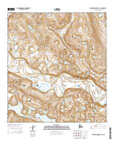
2015 Map of Misheguk Mountain A-1 SE
USGS Topo · Published 2015About this map
Noatak National Preserve encompasses this entire Arctic landscape, defined by the winding course of the Noatak River as it meanders through the Northwest Arctic Borough. The river’s path creates a complex network of braids and oxbows, accompanied by numerous unnamed ponds and wetlands across the valley floor. To the south, the terrain holds significant water bodies including Lake Kangilipak and Okoklik Lake, which are situated amidst the undulating contours of the lowlands. Tributaries like Itimtikrak Cr feed into the primary river system from the north, illustrating the hydrological drainage patterns characteristic of this remote wilderness. The map is marked by township and range lines, such as t31n r2w, which provide a colonial grid over an otherwise untamed geography of high-latitude tundra and glacial legacies.
Find a feature on this map
11 named features on this map. Tap any name to fly to it.
Don’t see what you’re looking for? This feature index may not catch every label — zoom into the map to look around manually.
Map Details
Editions of this 2015 Misheguk Mountain A-1 SE Map
This is the sole edition of this map. No revisions or reprints were ever made.
Other maps of this area

1951 · Baird Mountains
USGS Topo · 1:250,000

1951 · Howard Pass
USGS Topo · 1:250,000

1951 · Ambler River
USGS Topo · 1:250,000

1951 · Misheguk Mountain
USGS Topo · 1:250,000

1956 · Howard Pass
USGS Topo · 1:250,000

1956 · Ambler River
USGS Topo · 1:250,000

1956 · Misheguk Mountain
USGS Topo · 1:250,000

1956 · Baird Mountains
USGS Topo · 1:250,000

1964 · Ambler River
USGS Topo · 1:250,000

1965 · Baird Mountains
USGS Topo · 1:250,000