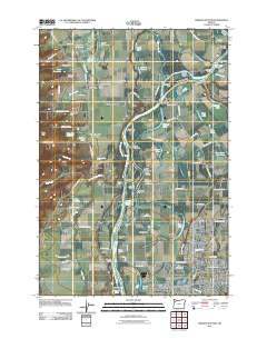
2011 Map of Mission Bottom
USGS Topo · Published 2011About this map
The Willamette River meanders through this portion of the valley, carving out a complex landscape of islands, bars, and sloughs north of Keizer. The western bank is defined by the elevation of Jerusalem Hill and the Eola Hills, while the low-lying interior contains Mission Bottom and the expansive Willamette Mission Park. This area preserves traces of early settlement patterns, from the river-crossing at Wheatland Ferry to the small communities of Hopewell and Lincoln. Historical research is supported by the inclusion of Hopewell Cemetery and Claggett Cemetery, alongside numerous water features like Mission Lake and Eldridge Slough that reflect the river's shifting path over time. The southern portion of the map shows the transition into more developed residential areas near Keizer and the Clear Lake Golf Course.
Find a feature on this map
108 named features on this map. Tap any name to fly to it.
Don’t see what you’re looking for? This feature index may not catch every label — zoom into the map to look around manually.
Map Details
Editions of this 2011 Mission Bottom Map
This is the sole edition of this map. No revisions or reprints were ever made.
Other maps of this area

1915 · Rickreall
USGS Topo · 1:31,680

1915 · Eola
USGS Topo · 1:31,680

1917 · Salem
USGS Topo · 1:62,500

1923 · Mount Angel
USGS Topo · 1:62,500

1924 · Mc Minnville
USGS Topo · 1:48,000

1925 · Stayton
USGS Topo · 1:62,500

1926 · Mc Minnville
USGS Topo · 1:62,500

1940 · McMinnville
USGS Topo · 1:62,500

1940 · Salem
USGS Topo · 1:62,500

1940 · Mount Angel
USGS Topo · 1:62,500