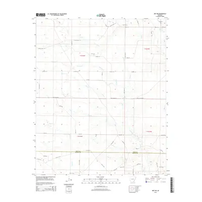
2014 Map of Mist NW
USGS Topo · Published 2014About this map
Drew Co Ashley Co border country in southeastern Arkansas is defined by an intricate network of timber roads and drainage creeks. This rural landscape is heavily marked by its forestry and agricultural history, with major thoroughfares like Gates Mainline Rd and Lower Gates Mainline providing access through the creek bottoms. Small, family-named burial grounds including Centerpoint Cem, Jordan Cem, and Cotham Cem serve as vital markers for local genealogy, often located near intersections of older routes like Pleasant Grove RD. The presence of the Old Tram Rd suggests the legacy of early logging railroads that once moved timber through the lowlands surrounding Bearhouse Cr and Gillam Cr. The terrain is also etched with numerous trails such as Thompson TRL and Peterson TRL, which wind between the various branches of Holley Cr and Haw Cr.
Find a feature on this map
56 named features on this map. Tap any name to fly to it.
Don’t see what you’re looking for? This feature index may not catch every label — zoom into the map to look around manually.
Map Details
Editions of this 2014 Mist NW Map
This is the sole edition of this map. No revisions or reprints were ever made.
Other maps of this area

1935 · Mist
USGS Topo · 1:62,500

1935 · Cominto
USGS Topo · 1:62,500

1952 · Fountain Hill
USGS Topo · 1:24,000

1953 · Greenwood
USGS Topo · 1:250,000

1956 · Greenwood
USGS Topo · 1:250,000

1960 · Snyder
USGS Topo · 1:24,000

1960 · Mist
USGS Topo · 1:62,500

1960 · Collins
USGS Topo · 1:24,000

1960 · Collins
USGS Topo · 1:62,500
1960 · Line
USGS Topo · 1:24,000