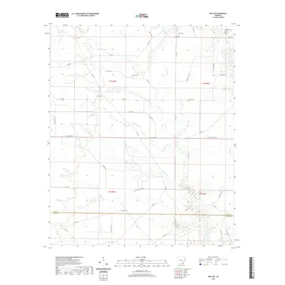
2020 Map of Mist NW
USGS Topo · Published 2020About this map
Bearhouse Cr and Gilliam Cr carve through this timber and drainage-rich landscape where Drew and Ashley Counties meet. The presence of Old Tram Rd provides a clear link to the area's historical logging operations, while the scattering of family and community burial grounds, such as Jordan Cem and Judkins Cem, anchors the genealogy of the surrounding rural countryside. The terrain is defined by a dense network of watercourses, including Holley Cr and Wolf Cr, which historically influenced road placement and land use. Contemporary access is facilitated by a grid of designated routes like Gates Mainline Rd and Baptist Camp Rd, reflecting a landscape that continues to balance industrial timber management with local residency. This map offers a detailed view of the small-scale landmarks and hydraulic patterns that have shaped this pocket of southeastern Arkansas.
Find a feature on this map
54 named features on this map. Tap any name to fly to it.
Don’t see what you’re looking for? This feature index may not catch every label — zoom into the map to look around manually.
Map Details
Editions of this 2020 Mist NW Map
This is the sole edition of this map. No revisions or reprints were ever made.
Other maps of this area

1935 · Mist
USGS Topo · 1:62,500

1935 · Cominto
USGS Topo · 1:62,500

1952 · Fountain Hill
USGS Topo · 1:24,000

1953 · Greenwood
USGS Topo · 1:250,000

1956 · Greenwood
USGS Topo · 1:250,000

1960 · Snyder
USGS Topo · 1:24,000

1960 · Mist
USGS Topo · 1:62,500

1960 · Collins
USGS Topo · 1:24,000

1960 · Collins
USGS Topo · 1:62,500
1960 · Line
USGS Topo · 1:24,000