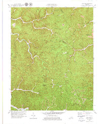
1979 Map of Mistletoe
USGS Topo · Published 1979About this map
Mistletoe serves as a central point in this part of Owsley County, where the landscape is defined by the winding paths of Buffalo Creek and Bullskin Creek. The terrain is marked by numerous family-named branches and forks, such as Upper Allen Branch and Little McJunkin Br, reflecting a long history of local settlement and land divisions. By the late 1970s, the area's geography shows a mix of traditional Appalachian creek-bottom communities and modern industrial activity, with several Strip Mines appearing along the ridges of the Owsley and Perry County line.
Find a feature on this map
72 named features on this map. Tap any name to fly to it.
Don’t see what you’re looking for? This feature index may not catch every label — zoom into the map to look around manually.
Map Details
Editions of this 1979 Mistletoe Map
This is the sole edition of this map. No revisions or reprints were ever made.
Other maps of this area

1891 · Manchester
USGS Topo · 1:125,000

1891 · Hazard
USGS Topo · 1:125,000

1913 · Buckhorn
USGS Topo · 1:62,500

1916 · Hyden
USGS Topo · 1:48,000

1919 · Hyden
USGS Topo · 1:62,500

1953 · Buckhorn
USGS Topo · 1:24,000

1953 · Oneida
USGS Topo · 1:24,000

1953 · Cowcreek
USGS Topo · 1:24,000

1953 · Hyden West
USGS Topo · 1:24,000

1953 · Big Creek
USGS Topo · 1:24,000