
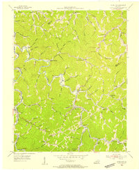
1953 Map of Hyden West
USGS Topo · Published 1954About this map
The Hyden area of the Kentucky mountains is captured in this early 1950s record, showing a landscape defined by its deep hollows and namesake creeks. Near the Leslie and Perry county line, the map documents a high density of rural schools and family-centered landmarks, such as Upper Hell for Certain Sch and Lower Hell for Certain Sch along the curiously named waters of Hell. These small educational outposts, including Piney Grove Sch and Hals Fork Sch, reflect the isolated nature of mountain life before the extensive consolidation of the late twentieth century.
Find a feature on this map
93 named features on this map. Tap any name to fly to it.
Don’t see what you’re looking for? This feature index may not catch every label — zoom into the map to look around manually.
Map Details
Editions of this 1953 Hyden West Map
This is the sole edition of this map. No revisions or reprints were ever made.
Other maps of this area

1891 · Manchester
USGS Topo · 1:125,000

1891 · Hazard
USGS Topo · 1:125,000

1913 · Buckhorn
USGS Topo · 1:62,500

1916 · Hyden
USGS Topo · 1:48,000

1919 · Hyden
USGS Topo · 1:62,500

1953 · Buckhorn
USGS Topo · 1:24,000

1953 · Big Creek
USGS Topo · 1:24,000

1953 · Mistletoe
USGS Topo · 1:24,000

1954 · Krypton
USGS Topo · 1:24,000
1954 · Hyden East
USGS Topo · 1:24,000