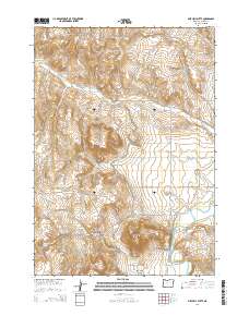
2014 Map of Mitchell Butte
USGS Topo · Published 2014About this map
Mitchell Butte and the surrounding volcanic terrain of Malheur County define this high-desert landscape in the early 21st century. The southeastern corner is anchored by the Owyhee River, where the Mitchell Butte Hot Spring and the Rock Spring Siphon indicate the intersection of geothermal activity and essential water infrastructure in an arid region. The topography is dominated by prominent landforms such as Chalk Butte and Deer Butte, alongside elevated plateaus like Lincoln Bench and Owyhee Bench. The map records an intricate network of rural routes, including Cow Hollow Rd and Mitchell Butte Rd, which navigate the deep drainages of Johnson Gulch and Fletcher Gulch. This survey provides a clear view of the complex hydrography and land management within these townships, tracing the movement of water from Chalk Spring through the canyons.
Find a feature on this map
41 named features on this map. Tap any name to fly to it.
Don’t see what you’re looking for? This feature index may not catch every label — zoom into the map to look around manually.
Map Details
Editions of this 2014 Mitchell Butte Map
This is the sole edition of this map. No revisions or reprints were ever made.
Other maps of this area

1906 · Mitchell Butte
USGS Topo · 1:125,000

1955 · Boise
USGS Topo · 1:250,000

1958 · Boise
USGS Topo · 1:250,000

1962 · Boise
USGS Topo · 1:250,000
1967 · Vale East
USGS Topo · 1:24,000
1967 · Cairo
USGS Topo · 1:24,000
1967 · Owyhee Dam
USGS Topo · 1:24,000
1967 · Vale West
USGS Topo · 1:24,000
1967 · Double Mtn
USGS Topo · 1:24,000
1967 · Adrian
USGS Topo · 1:24,000