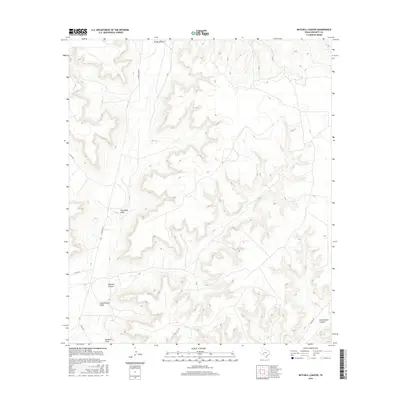
2016 Map of Mitchell Canyon
USGS Topo · Published 2016About this map
Mitchell Canyon and Government Canyon define the landscape of this portion of Crockett County, where a network of ephemeral watercourses has carved deep paths through the high plains. The drainage patterns are dominated by Howard Draw and Escondido Draw, which flow through the west and central portions of the quadrangle. These natural corridors long dictated the layout of the local transportation network, seen here in the placement of Howard Draw Rd. and Pandale Rd. While the area remains largely undeveloped, the map details several county roads, including Co Rd 405 and Co Rd 407, that provide access to this isolated ranching country. The intricate contour lines reveal the complex topography of the Government Draw basin, offering a precise look at the land's character before modern changes or large-scale land use shifts.
Find a feature on this map
9 named features on this map. Tap any name to fly to it.
Don’t see what you’re looking for? This feature index may not catch every label — zoom into the map to look around manually.
Map Details
Editions of this 2016 Mitchell Canyon Map
This is the sole edition of this map. No revisions or reprints were ever made.
Other maps of this area

1929 · Sheffield
USGS Topo · 1:125,000

1954 · Sonora
USGS Topo · 1:250,000

1958 · Sonora
USGS Topo · 1:250,000

1967 · Burnt Canyon
USGS Topo · 1:24,000

1967 · Pikes Peak
USGS Topo · 1:24,000

1967 · Hunt Ranch
USGS Topo · 1:24,000

1967 · Bachelor Hill
USGS Topo · 1:24,000
1967 · Mitchell Canyon NE
USGS Topo · 1:24,000

1967 · Mitchell Canyon
USGS Topo · 1:24,000

1970 · Howards Well NE
USGS Topo · 1:24,000