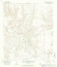
1967 Map of Mitchell Canyon NE
USGS Topo · Published 1971About this map
Eureka Draw carves a deep path through this section of Crockett County, serving as the central drainage for a landscape defined by industrial development in the late 1960s. The map captures an era of active resource extraction, indicated by numerous Gas Wells, an Oil Well, and several scattered Drill Holes. Infrastructure supporting this activity is clearly marked, including a complex Pipeline network and a dedicated Pumping Station. A remote Landing Strip and a prominent Water Tank suggest the logistical requirements of operating in this isolated terrain. Several Gravel Pits are also noted, likely utilized for the construction of the local road and utility network that crisscrosses the draw.
Find a feature on this map
10 named features on this map. Tap any name to fly to it.
Don’t see what you’re looking for? This feature index may not catch every label — zoom into the map to look around manually.
Map Details
Editions of this 1967 Mitchell Canyon NE Map
This is the sole edition of this map. No revisions or reprints were ever made.
Other maps of this area

1954 · Sonora
USGS Topo · 1:250,000

1958 · Sonora
USGS Topo · 1:250,000

1967 · Ozona
USGS Topo · 1:24,000

1967 · Baggett Ranch
USGS Topo · 1:24,000

1967 · Pikes Peak
USGS Topo · 1:24,000
1967 · Schneeman Draw SW
USGS Topo · 1:24,000

1967 · Indio Hill
USGS Topo · 1:24,000

1967 · Hunt Ranch
USGS Topo · 1:24,000
1967 · Schneeman Draw SE
USGS Topo · 1:24,000

1967 · Mitchell Canyon
USGS Topo · 1:24,000