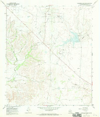
1967 Map of Schneeman Draw SE
USGS Topo · Published 1970About this map
The Vaughn Oil Field dominates this central Crockett County landscape, showing the distribution of industrial infrastructure across the high desert terrain of West Texas. Numerous Oil Wells and a network of pipelines are interspersed with the natural drainage systems of Garrett Draw, Pikes Peak Draw, and Newton Draw. The topography is anchored by the prominent elevation of Pikes Peak in the southwest, while a large reservoir and Spillway Elev 2574 indicate the management of seasonal water flow in this arid region. These features reflect the mid-century intersection of petroleum extraction and ranching land use, where the dry creek beds and rocky outcrops were shared by drilling operations and local livestock. The map also records several scattered Gravel Pits and numerous exploratory Drill Holes, providing a clear record of the geological surveying and resource development defining the area in the late 1960s.
Find a feature on this map
9 named features on this map. Tap any name to fly to it.
Don’t see what you’re looking for? This feature index may not catch every label — zoom into the map to look around manually.
Map Details
Editions of this 1967 Schneeman Draw SE Map
This is the sole edition of this map. No revisions or reprints were ever made.
Other maps of this area

1954 · Sonora
USGS Topo · 1:250,000

1958 · Sonora
USGS Topo · 1:250,000

1967 · Ozona
USGS Topo · 1:24,000

1967 · Schneeman Draw NW
USGS Topo · 1:24,000
1967 · Schneeman Draw NE
USGS Topo · 1:24,000

1967 · Pikes Peak
USGS Topo · 1:24,000
1967 · Schneeman Draw SW
USGS Topo · 1:24,000

1967 · Indio Hill
USGS Topo · 1:24,000

1967 · Double Mill Draw NW
USGS Topo · 1:24,000
1967 · Mitchell Canyon NE
USGS Topo · 1:24,000