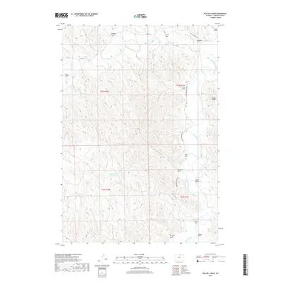
2017 Map of Mitchell Draw
USGS Topo · Published 2017About this map
Powder River drainage systems define this section of Johnson County, where a complex network of draws and seasonal watercourses navigate a dissected landscape. The presence of the Henry Number 1 Reservoir stands out as a critical point of water management within the arid terrain, situated south of Kinney Divide. The map illustrates the region's reliance on intermittent water sources, with named features such as Crazy Woman Cr and Mitchell Draw carving distinct paths through the topography.
Find a feature on this map
22 named features on this map. Tap any name to fly to it.
Don’t see what you’re looking for? This feature index may not catch every label — zoom into the map to look around manually.
Map Details
Editions of this 2017 Mitchell Draw Map
This is the sole edition of this map. No revisions or reprints were ever made.
Other maps of this area

1955 · Sheridan
USGS Topo · 1:250,000

1958 · Sheridan
USGS Topo · 1:250,000

1962 · Sheridan
USGS Topo · 1:250,000

1972 · Mitchell Draw
USGS Topo · 1:24,000
1972 · Bear Draw
USGS Topo · 1:24,000
1972 · Lariat
USGS Topo · 1:24,000
1972 · Jewell Draw
USGS Topo · 1:24,000
1972 · Somerville Flats West
USGS Topo · 1:24,000
1972 · Floate Draw
USGS Topo · 1:24,000
1972 · Arpan Butte
USGS Topo · 1:24,000